A long year as it is a leap year. As the leap day occurs at the end of February, it makes winter one day longer. No matter whether you use the meteorological definition of winter, the months of December, January and February, or the astronomical definition as the period between the winter solstice and the spring or vernal equinox – a leap year makes for a long winter!
This year, the drainage team were working on leap day – so making five Thursdays in February. If we stick to Thursdays, it will be 28 years before we work on 29th February again!
Thursday 22nd February
The five members of the team attending unanimously agreed it was the wettest day so far this year. Torrential rain early morning and heavy rain in the afternoon, with just a brief interlude in the middle - but even that had drizzle. The only improvement from two weeks ago was that the puddles in Winchcombe yard were not quite so deep.
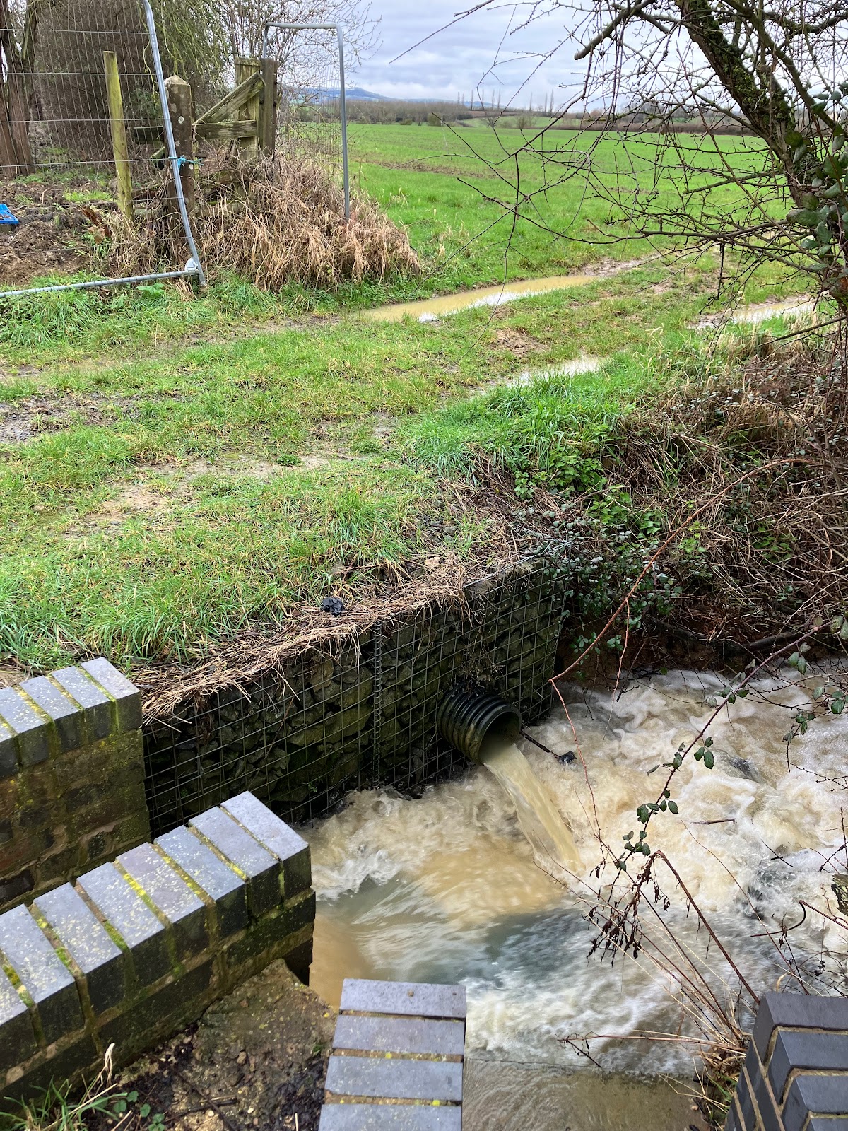
Consequently no work was achieved on the low mileage up side wing wall of the River Isbourne bridge. The level of the river was only 1 inch below the brick course we demolished last week.
 |
| High and fast flow in the River Isbourne. |
In the comparative dry of the old wooden workshop we were able to make progress on milepost manufacture. Some lengths of bridge rail were painted with black hammerite and half a dozen new heads given another coat of gloss white.
The telehandler was used to undertake a bit more of the tidy up of Winchcombe Yard - mainly levelling up with small debris/soil near the gravel bin.
When the rain eased off, we spilt into to two teams to inspect various places north of Winchcombe. Some of this was planned - some was to check the results of the heavy rain of the past few days.
Dave & Nigel went first to Meadow Lane bridge (6) at Laverton. The road underneath is flooded - probably because the roadside exit drains (not railway responsibility) are blocked with debris and silt washed from the fields (mainly the adjacent field on the down side high mileage of the bridge). They were not able to reach the grills under the bridge to rake them out as the depth of water was over 3 foot - well over wellington boot height.
 | |
| Meadow Lane bridge 6, Laverton - 3 feet of water. [Photo by Dave] |
 |
| Says it all! [Photo by Dave] |
Next they checked bridge 5, Little Buckland. Just puddles under that, no flooding. Then on to Stanton to check on 11A and 11B. 11A was flowing fast and vigorous - about two thirds up the brick U channel. The outlet of the 11B up side diversion was also flowing strongly.
 |
| The 11B diversion exit (black plastic pipe) into the turbulent 11A stream. [Photo by Dave] |
Jonathan, Roger and Andrew undertook the checking of the Winchcombe to Toddington section. First stop was cross drain 19A - for the first time we saw water flowing through this. There is no real stream inlet on the down side - just field run off. Also no stream outlet on the up side - just water in one of the medieval field furrows.
 |
| Rare photo of water flowing out of cross drain 19A and across the field in one of the medieval furrows. |
Next was culvert 17B - the up side inlet under the footpath bridge was like Niagara falls. With the recent major clearance by Tom Clarke with robo flail and tractor mounted flail we could see water running by the boundary on the low mileage up side of the culvert - and back in a shallow ditch to the up side cess outlet. Again , we have never seen this running with water. We added clearing of the cess outlet to the open job list. Then along to the next one, bridge 17A. This was one of the planned visits, as damage had been reported to the high mileage up side cess outlet which enters the outlet stream. This turned out to be significant damage to the 12 inch diameter SGP pipes, which are only a few inches below the surface. We dug out several lengths to ensure no blockage. A full repair here will need most of this pipe back to the first cess chamber excavated and replaced with 300mm plastic twinwall pipe. The lower end of this cess outlet was replaced when major work on the bridge 17A was done - now over 10 years ago. We checked the down side as well - it was flowing well from the steam, two field drains and the high mileage down cess.
 |
| Culvert 17B inlet (down or Cotswold side). The footpath bridge is not GWSR responsibility. |
 |
| Culvert 17B low mileage up (Malvern) side - we can now see where the cess outlet runs. |
 |
| Damage to SGP pipe taking high mileage up side cess to the 17A outlet. (As 17A is a large structure it is a bridge, not a culvert, even though it is over a stream). |
Heading north we noticed a slightly broken cess chamber lid at Hayles Abbey halt. On further inspection this also has a fractured top concrete ring that will need replacing - with the last concrete ring we have in stock.
Then the final planned inspection at culvert 14B, just north of Didbrook No1 bridge. The down side ditch which takes the excess from culvert 14A into the low mileage end of the input stream was a torrent - a mini High Force waterfall. No wonder that there is a lot of undercutting here. Infill was added a few years ago but has all been washed away. With the boundary fence line on the high mileage end now cleared back to the 'gate' by Didbrook No1 bridge; it would be possible to get a bit closer with the dumper. However not close enough to the low mileage end for direct tipping of material. The proper solution to this will be construction of waterfall steps - either concrete or GRP sections. Definitely a summer job - and maybe best contracted out. Finally we checked the flow on the down side around 14A; the surface flow on the upstream (low mileage) and the downstream of the 14 entrance appeared to be equal. So it looks like very little flows through 14A - it is only a 4 inch pipe and the exit location is unknown.
 |
| The 14A to 14B overflow ditch on the down side undercutting near the entry to the 14B stream. |
We did not venture down the slippery embankment to the up side (outlet) of 14B - but from above it looked like the pond was almost overflowing. The outlet from the undersized pipe in the adjoining property was like a jet wash. All now visible following the major clearance work - so too is the Didbrook terminus of the narrow gauge line.
 |
| A view not seen for many years - the Didbrook end of the narrow gauge line from the embankment near culvert 14B. |
Wildlife report:
Didbrook:
Woodpecker (probably a greater spotted - it was heard rather than
seen); low flying red kite. Plant wise several early flowering
primroses on the up side embankment - shows what grows when bramble
and scrub removed.
 |
| Vegetation thinks it is spring - pity the weather does not agree! |
Winchcombe - magpie, a bird that surprisingly we have not recorded before.
Thursday 29th February
Six team members working on the leap day. Weather wise it was the least wet for a few weeks, and the water levels in the Isbourne and streams had fallen. But it was still too wet for bricklaying on the Isbourne bridge wing wall. So we tackled a variety of other jobs.
Two team members headed to Laverton Meadow Lane bridge (6). Again they were not able to check the gulleys under the bridge. Although the water depth had dropped to around 18 inches, this is still too deep for wellies and when 4x4 vehicles or tractors pass through the flood water the bow wave created would drench the workers. There was an abandoned BMW on the road which had obviously found the water too deep to pass.
 |
| Meadow Lane Bridge 6, Laverton. Abandoned BMW - this is what happens whey you ignore road closed signs and drive through flood water. [Photo by Stuart] |
The other four of the team recovered an unused concrete chamber ring from the down side near Greet Tunnel. This is the last spare concrete ring we have, it was going to be part of the a new chamber on the end of the cutting crest pipe. But the need of the damaged up side cess chamber at Hayles Abbey was greater. So the combined team assembled at Hayles Abbey; removed the damaged top ring from the cess chamber; inserted the new ring and replacement lid. Quite a straightforward operation - even with the distraction of two light engine and two ECS train movements. (Nice to see moving trains again!)
 |
| Damage lid replaced with metal grill, top concrete ring replaced and some marker stones added. Up side cess chamber opposite the platform at Hayles Abbey Halt. |
 |
| 47105 hauls the second coach set (we can not call it the maroon set now) to Toddington through Hayles Abbey Halt. |
Then on to the damaged up side cess pipe on the high mileage side of bridge (big culvert) 17A. We measured up for the replacement 300mm diameter twinwall pipe and covered the section of excavated damaged pipe with blue mesh covers. Another job that needs some drier weather to progress (and some 300mm pipe too!).
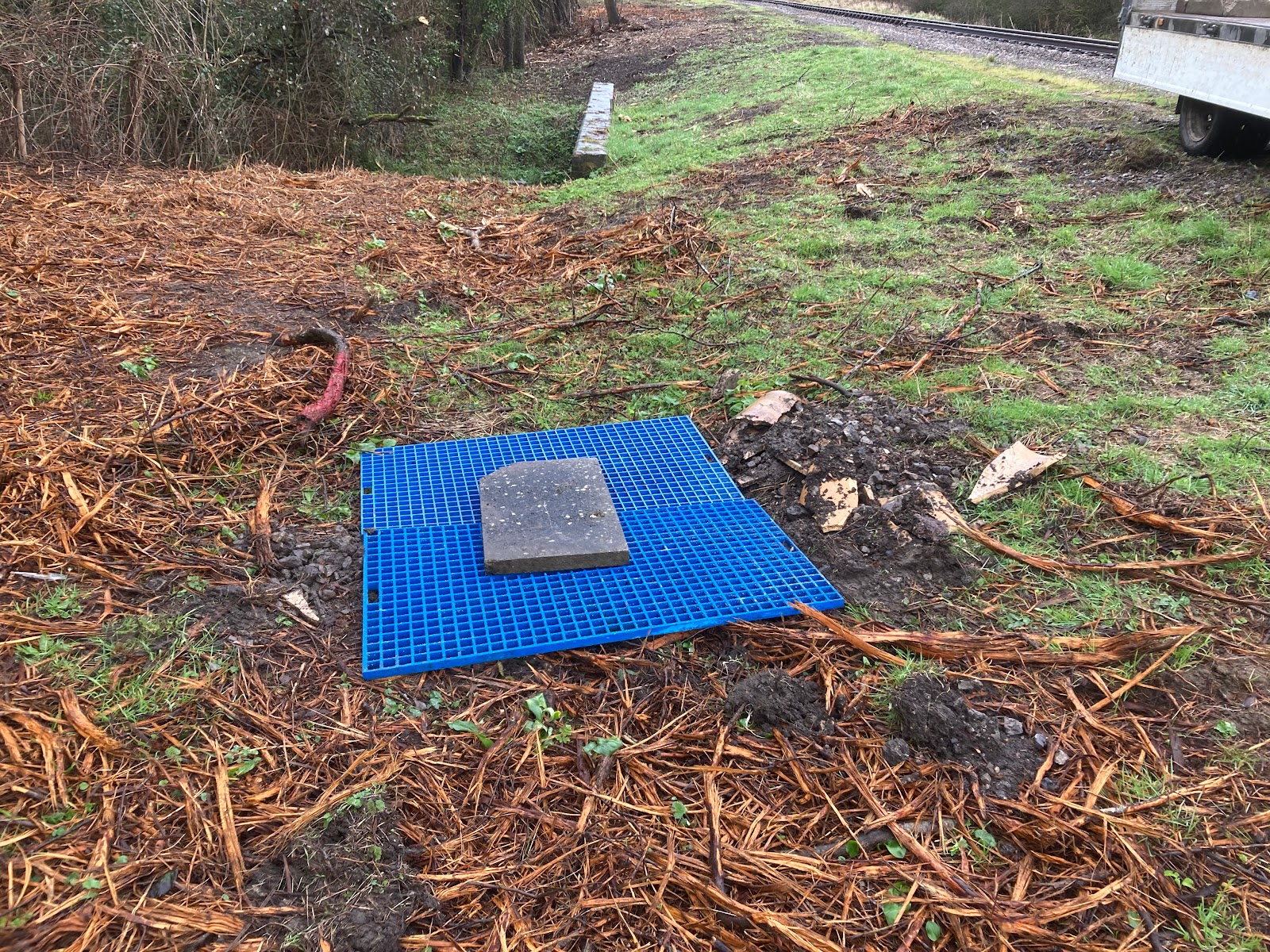 |
| The damaged concrete lid from the chamber at Hayles Abbey was put to use to weigh down the blue mesh covers temporarily protecting the expose cess drain pipe at 17A. |
Next back to Winchcombe and more milepost preparation. Mainly this was painting lengths of bridge rail and preparing the lengths recovered from Cheltenham Racecourse for painting. After lunch four of the team headed to Prescott Road bridge to install new milepost 14½. This used the length of bridge rail which was intended for mile post 9¼ at Toddington North. That will now be replaced when other work in Toddington North cutting is completed.
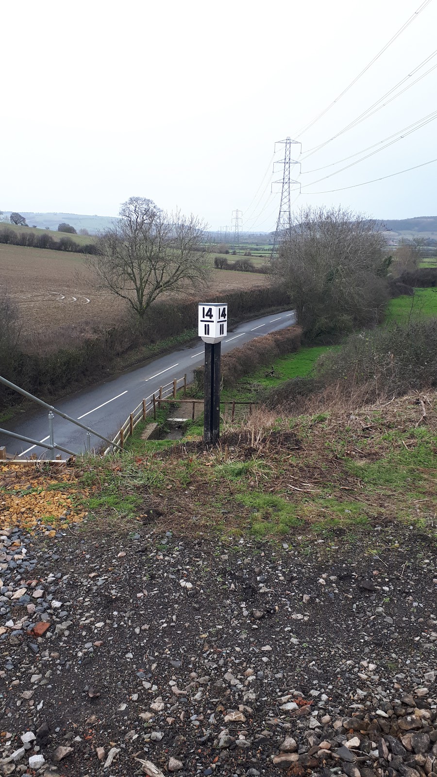 |
| Milepost 14 and half now properly set on bridge rail - previously the BR style yellow head was attached to the bridge parapet. [Photo by Roger] |
The heritage fans amongst our readers will be glad to know that the numerals, dividers and quarter marks on the replacement mileposts are screwed in with conventional slotted brass screws – not crossheads. But the screw heads are painted black to hide them; so unless you look very closely you would not notice! If you want to inspect a milepost close up; milepost 12 is on platform 2 at Winchcombe.
On the way back from Prescott Road the group cleared the outfall grating on the exit of culvert 24C; as usual a few weeks worth of twigs and leaves was causing a restriction. Also they observed the progress on the glamping pods at the Royal Oak pub. With the Railway’s permission, land drainage from this area will flow into the inlet of culvert 24A. This will lead to quite an increase in the flow through the culvert, so we will be adding more scour prevention on the up side outlet downstream of the haul road.
 | |
| Nigel clears the exit grill of culvert 24C outlet - water level then dropped several inches. [Photo by Dave] |
The other two team members installed a (temporary) rope handrail on the up side access to the Isbourne Bridge. When we finally can get to progress the rebuild; we will have to mix the mortar at the top of the embankment and transport it down the wing wall in buckets.
 |
| Jonathan undertakes the test of the temporary rope handrail on the up side access to the Isbourne bridge. |
Wildlife report:
We heard several sky larks, and two woodpeckers but once again no sighting so we are yet to determine exactly what species they are (we suspect great spotted). Also noted at Gotherington were lots of Canada geese and lots of rabbits.
As of Saturday (2nd March) the water level at Laverton bridge was just under 4ft and was reaching the tops of the wheel arches of the unfortunate Bremer. David
ReplyDeleteLaverton Bridge gully drains...a contentious dilemma! Whilst HofD I contacted Glos Highways Dept regarding said gully drains and was informed that being a rail over road bridge where the road had been lowered to accommodate a level railway line, the drains were actually the responsibility of the railway. As a gesture of goodwill they (Glos Highways) did send out a gully pump to clean out the 3 drains that were evident. We also spent a number of weeks clearing the cross drains and installing silt traps to either side of the road.
ReplyDeleteWhen heavy rains were forecast, a team member with rake and brush was sent out each day (admittedly we were working six days a week then) to clear debris from said gully grates. For 8 years we had no flooding at all. The same regime for Didbrook 2 Bridge and Far Stanley Bridge. The gully drains in Station Road, Bishops Cleeve need periodically clearing during winter aswell.
Thanks for the explanation Andy. But being the lowest point in the local terrain where does accumulated flood water under the bridge drain to ?
ReplyDeleteDavid, The water entering these gully drains feeds into a (far too small) pipe that is buried in the grass verge beside Meadow Lane heading in the direction of Wormington. We were able to come by some detailed drawings showing the levels, and was astounded that water actually travelled along this pipe...the gradient is almost non existent! To that end, if the gullies are not cleared of silt on a very regular basis, then the silt overspills and is washed into the course of the pipe. Because the flow rate is so slow, the silt builds up reducing the effectiveness further still. Due to the lay of the land, this was the best that could be achieved. Didbrook Bridge has a similar issue.
ReplyDeleteHope that helps.
Andy.
Once again thanks Andy. I was curious as to where the water was supposed to go as, obviously, not all it will simply evapourate off. From your description of the pipe it sounds like it's needs some expensive kit to be brought in to keep it clear, namely a jetter with a very long hose.
ReplyDeleteAndy and Dave, thanks for the comments. Meadow Lane has probably seen the worst effects of the prolonged wet autumn, winter and early spring. See the next blog post "Always something new to discover" of 23rd March.
Delete